A) Observe the entire landscape first and then focus on smaller parts, one part at a time.
B) Examine complexities of each feature rather than grouping features into types.
C) Focus on one type of feature at a time, noting where this type of feature is present.
D) Examine relationships between different features.
F) None of the above
Correct Answer

verified
Correct Answer
verified
Multiple Choice
The oldest unit or feature in this photograph is: 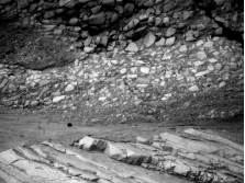
A) the rock at the top that contains angular fragments
B) the gray layer in the middle of the photograph
C) the tilted rocks at the bottom
D) there is no way to tell
F) C) and D)
Correct Answer

verified
Correct Answer
verified
Multiple Choice
The rock in this photograph mostly likely formed in: 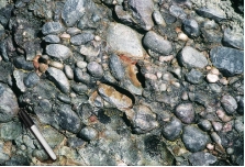
A) a steep mountain front
B) a river
C) a sand dune
D) deep water conditions on the seafloor
F) None of the above
Correct Answer

verified
Correct Answer
verified
Multiple Choice
The feature shown is a smaller, steep-sided mountain and has had its edges eroded away. This feature would commonly be called a: 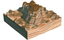
A) butte
B) mesa
C) knob
E) All of the above
Correct Answer

verified
Correct Answer
verified
Multiple Choice
The Mediterranean Sea is connected with the Atlantic Ocean through the:
A) Strait of Gibraltar
B) Red Sea
C) Nile River
D) Black Sea
F) All of the above
Correct Answer

verified
Correct Answer
verified
Multiple Choice
The formula to determine an object's average rate of movement is:
A) distance/time
B) time/distance
C) time/speed
D) speed/time
F) A) and C)
Correct Answer

verified
Correct Answer
verified
Multiple Choice
Which of the following could be associated with a steep slope?
A) a mountain side
B) a cliff
C) closely spaced contour lines
D) all of these
F) A) and B)
Correct Answer

verified
Correct Answer
verified
Multiple Choice
This figure shows three blocks in water. Which of these materials is the least dense? 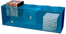
A) block 1
B) block 2
C) block 3
D) the water 4
F) A) and D)
Correct Answer

verified
Correct Answer
verified
Multiple Choice
Which letter on the accompanying figure indicates depth? 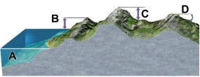
A) A
B) B
C) C
D) D
F) All of the above
Correct Answer

verified
Correct Answer
verified
Multiple Choice
What is the oldest unit or feature in this figure? 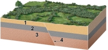
A) 1
B) 2
C) 3
D) 4
E) there is no way to tell
G) B) and D)
Correct Answer

verified
Correct Answer
verified
Multiple Choice
Which of the following is data rather than an interpretation?
A) Some trees along Yellowstone Lake were flooded when the land north of the lake rose because of magma at depth.
B) Rising and sinking of the land around Yellowstone is related to underlying magma.
C) The ages of volcanic centers near Yellowstone indicate that North America is moving southwest over the mantle.
D) All of these are data rather than interpretations.
E) All of these are interpretations rather than data.
G) C) and D)
Correct Answer

verified
Correct Answer
verified
Multiple Choice
Which letter on the accompanying figure indicates the amount of topographic relief? 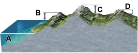
A) A
B) B
C) C
D) D
F) None of the above
Correct Answer

verified
Correct Answer
verified
Multiple Choice
Which of the following is true about density and weight?
A) density is higher if you have a larger volume of the same material
B) density is lower if you have a larger volume of the same material
C) a substance is more dense at night than during the day
D) weight depends on the mass of the object and the pull of gravity
E) none of these
G) A) and D)
Correct Answer

verified
Correct Answer
verified
Multiple Choice
Which of the following are true for an evolutionary diagram?
A) Uses a sequence of geologic diagrams to depict the geologic history of an area.
B) May use block diagrams, cross sections, or maps.
C) Shows the progression of changes an area undergoes through time.
D) All of these.
F) A) and C)
Correct Answer

verified
Correct Answer
verified
Multiple Choice
Which locations contain rocks that are in place part of the bedrock) ? 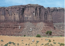
A) 1 and 2
B) 2 and 3
C) 3 and 4
D) 1 and 3
E) 2 and 4
G) A) and E)
Correct Answer

verified
Correct Answer
verified
Multiple Choice
Which of the following is an example of quantitative data?
A) Augustine volcano represents a dangerous situation
B) the rocks were dark gray and angular
C) the steam coming from the mountain was dark gray in color
D) the rocks were too hot to touch
E) none of these
G) C) and D)
Correct Answer

verified
Correct Answer
verified
Multiple Choice
If a stream flow measures 12 meters in 60 seconds, what is the stream's average rate of flow?
A) 0.2 m/s
B) 2 m/s
C) 0.5 m/s
D) 5 m/s
F) C) and D)
Correct Answer

verified
Correct Answer
verified
Multiple Choice
Which of the following may be interpreted from the sketch? 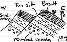
A) A fault has cut through the rock layers.
B) The fault is younger than all the rock layers present.
C) The oldest environment represented may have been a river channel, based upon the shape of the clasts.
D) All of these.
F) A) and D)
Correct Answer

verified
Correct Answer
verified
Multiple Choice
What type of map is shown here? 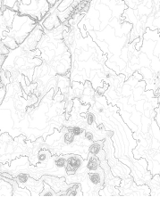
A) shaded-relief map
B) topographic map with contours
C) satellite image
D) geologic map
F) A) and B)
Correct Answer

verified
Correct Answer
verified
Multiple Choice
The vertical black lines indicated in rock units #3 and #4 indicate what type of feature? 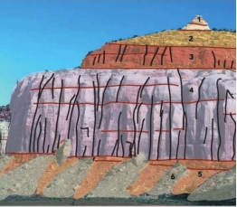
A) fractures
B) beddings
C) slopes
D) loose rock
F) None of the above
Correct Answer

verified
Correct Answer
verified
Showing 81 - 100 of 106
Related Exams