A) upper layer,fracture,middle layers,lowest layer
B) lowest layer,middle layers,fracture,upper layer
C) lower layer,middle layers,upper layer,fracture
D) none of these
F) None of the above
Correct Answer

verified
Correct Answer
verified
Multiple Choice
If you wanted to determine how deep a rock layer was below a particular point on the surface,what type of figure would be most useful?
A) shaded relief map
B) topographic map
C) satellite image
D) evolutionary diagram
E) geologic cross section
G) D) and E)
Correct Answer

verified
Correct Answer
verified
Multiple Choice
Which locations contain rocks that are in place (part of the bedrock) ? 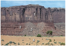
A) 1 and 2
B) 2 and 3
C) 3 and 4
D) 1 and 3
E) 2 and 4
G) B) and D)
Correct Answer

verified
A
Correct Answer
verified
Multiple Choice
Which letter on the accompanying figure indicates depth? 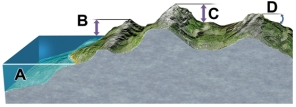
A) A
B) B
C) C
D) D
F) None of the above
Correct Answer

verified
Correct Answer
verified
Multiple Choice
The rock in this photograph mostly likely formed in: 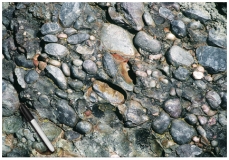
A) a steep mountain front
B) a river
C) a sand dune
D) deep water conditions on the seafloor
F) None of the above
Correct Answer

verified
B
Correct Answer
verified
Multiple Choice
Which type of map or diagram would best indicate elevation of the land surface?
A) shaded-relief map
B) satellite image
C) topographic map
D) stratigraphic section
F) None of the above
Correct Answer

verified
Correct Answer
verified
Multiple Choice
This figure shows the main subdivisions of the geologic timescale.Which of these is the Precambrian? 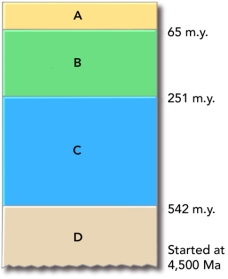
A) A
B) B
C) C
D) D
F) None of the above
Correct Answer

verified
Correct Answer
verified
Multiple Choice
Which of the following correctly lists the four main chapters of Earth's history,from oldest to youngest?
A) Paleozoic,Mesozoic,Cenozoic,Precambrian
B) Cenozoic,Mesozoic,Paleozoic,Precambrian
C) Paleozoic,Precambrian,Mesozoic,Cenozoic
D) Precambrian,Cenozoic,Mesozoic,Paleozoic
E) Precambrian,Paleozoic,Mesozoic,Cenozoic
G) A) and C)
Correct Answer

verified
Correct Answer
verified
Multiple Choice
Which of the following is a principle to interpret relative ages?
A) The youngest rock is on the bottom.
B) A geologic feature is older than any rock or feature it crosscuts.
C) A younger rock can include pieces of an older rock.
D) An older magma can bake or metamorphose younger rocks.
F) A) and C)
Correct Answer

verified
Correct Answer
verified
Multiple Choice
This figure shows the main subdivisions of the geologic timescale.Which of these is the Cenozoic? 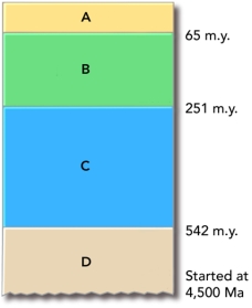
A) A
B) B
C) C
D) D
F) B) and C)
Correct Answer

verified
Correct Answer
verified
Multiple Choice
What type of map is shown here? 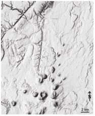
A) shaded-relief map
B) topographic map with contours
C) satellite image
D) geologic map
F) A) and C)
Correct Answer

verified
Correct Answer
verified
Multiple Choice
A key step in developing a new explanation is:
A) making observations about a place or process
B) asking questions about the observations
C) proposing an interpretation that can be tested
D) collecting new observations to test predictions
E) all of these
G) B) and E)
Correct Answer

verified
Correct Answer
verified
Multiple Choice
Which of the following represents the longest duration of geologic time?
A) Jurassic
B) Precambrian
C) Paleozoic
D) Mesozoic
E) Cenozoic
G) C) and E)
Correct Answer

verified
Correct Answer
verified
Multiple Choice
What strategy was described for inferring the environment in which a rock formed?
A) smashing the rock into pieces to see whether it breaks into square or rounded pieces
B) comparing the characteristics of the rock to deposits from modern environments
C) imagining what would happen if the rock was metamorphosed
D) all of these
F) None of the above
Correct Answer

verified
Correct Answer
verified
Multiple Choice
What can you interpret about the relative ages of the rocks and features in this photograph? 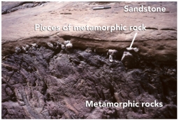
A) The sandstone is older because it is lighter in color.
B) The metamorphic rock is older because it is rougher from longer weathering.
C) The metamorphic rock is older because pieces of it are in the sandstone.
D) The sandstone is older because it is on top.
F) B) and C)
Correct Answer

verified
Correct Answer
verified
Multiple Choice
What is the youngest unit or feature in this figure? 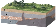
A) 1
B) 2
C) 3
D) 4
E) 5
G) A) and D)
Correct Answer

verified
E
Correct Answer
verified
Multiple Choice
Which letter on the accompanying figure indicates the elevation? 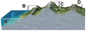
A) A
B) B
C) C
D) D
F) All of the above
Correct Answer

verified
Correct Answer
verified
Multiple Choice
If a runner races 50 meters in 5 seconds,how fast is she going?
A) 1 meter per second
B) 5 meters per second
C) 10 meters per second
D) 50 meters per second
E) none of these
G) None of the above
Correct Answer

verified
Correct Answer
verified
Multiple Choice
What type of map is shown here? 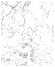
A) shaded-relief map
B) topographic map with contours
C) satellite image
D) geologic map
F) B) and D)
Correct Answer

verified
Correct Answer
verified
Multiple Choice
Which of the following would be most consistent with a volcanic origin for the Arizona crater discussed in the textbook?
A) a mass of salt should exist beneath the crater
B) meteorite fragments would be scattered across the area
C) solidified magma might underlie the crater floor
D) there will be no volcanic rocks because of the explosion
F) None of the above
Correct Answer

verified
Correct Answer
verified
Showing 1 - 20 of 61
Related Exams